
AI for every location decision.

Curated Intelligence™ — Location Decision Intelligence for business teams and GIS organizations. Curated connects natural-language AI, ArcGIS-powered analysis, and decision-ready artifacts in one shared workspace.

  • Built by an Esri Gold Partner
  • Connects to ArcGIS
  • Works with your data or standalone
Curated Intelligence™ answering a real estate location query alongside a live demographic map
Curated Intelligence™ workspace — natural-language analysis, ArcGIS-powered maps, and decision-ready outputs in one view.
01 / The Problem

The work behind location decisions
is still too manual.

Every team needs faster answers, but the work still gets routed through specialist queues, disconnected datasets, one-off research, and static reports. By the time the analysis is ready, the decision has already moved.

Specialist bottlenecks001

The demand for answers keeps outpacing the experts.

Business teams need spatial insight more often than GIS, analytics, and research teams can manually deliver it.

Disconnected data002

The evidence lives everywhere except together.

Internal data, market signals, public sources, premium datasets, and spatial layers all tell part of the story — rarely in one workflow.

Slow handoffs003

Analysis loses momentum as it moves between tools.

Questions become hunting expeditions for data, wrestling matches with analysis, and formatting headaches for reports.

Weak decision trails004

The final answer is hard to defend later.

Sources, assumptions, methodology, maps, and outputs often live separately, making the recommendation harder to explain in the room.

02 / The Shift

Location intelligence is becoming a team sport. Not another specialist workflow.

For decades, the work has lived inside GIS tools, data teams, and static reports. Curated brings it into a shared AI workspace — where teams can ask in natural language, explore the evidence, validate the methodology, and create the next thing the decision needs.

Now every team can gain the advantage of a geographic approach to decision-making.

03 / The Platform

Inside Curated Intelligence™

Curated Intelligence™ brings the question, data, map, methodology, and output into one workspace — helping teams move from location context to defensible decisions without jumping between disconnected tools.

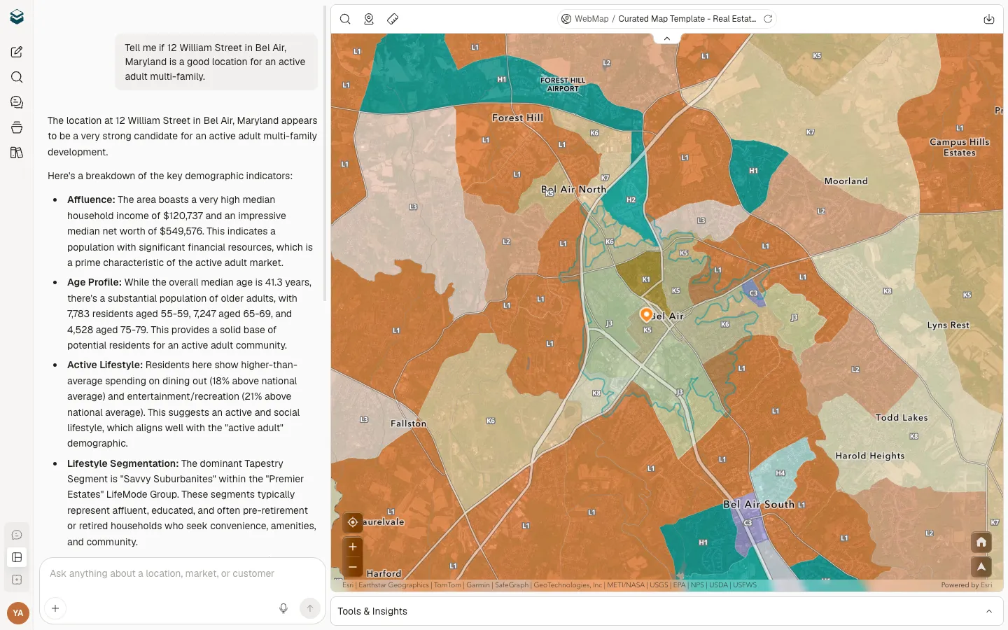
Start with the decision

Ask in natural language. Curated understands the business context.

Begin with a market, asset, customer, territory, campaign, site, or risk question. Curated interprets the intent and shapes the workflow around the decision — not around a tool menu.

Assemble the evidence

Data, research, maps, and playbooks come together automatically.

Curated pulls from spatial data, public sources, partner datasets, web research, customer layers, and expert methodology to build the complete picture around the question.

Inspect the reasoning

The team stays in control of the answer.

Curated keeps the evidence visible — sources, assumptions, methodology, map context, and supporting data — so teams can review, refine, and decide what becomes final.

Create the next artifact

The output matches the moment.

Turn analysis results and insights into a report, slide deck, interactive PlaceStory™, single-page HTML, image, map, campaign asset, or shareable workspace — so the decision can move forward.

04 / Use Cases

Built for the decisions your teams already make.

Curated supports the recurring decisions where location quietly shapes the outcome — from market strategy and asset planning to sales, risk, operations, and stakeholder communication.

Market and growth strategy

See where opportunity is forming before the market feels obvious.

Compare markets, identify underserved areas, evaluate demand signals, and understand where customers, competitors, and growth patterns are moving.

Site, asset, and territory decisions

Evaluate places with the context around them.

Analyze sites, properties, facilities, service areas, infrastructure, and territories with the surrounding data needed to decide what belongs where.

Portfolio and performance analysis

Understand which locations need attention next.

Review stores, assets, communities, branches, or markets to see what is strengthening, underperforming, exposed to risk, or ready for investment.

Sales and marketing intelligence

Turn place-based context into sharper action.

Use customer density, demographics, competitive presence, territory coverage, and local signals to guide campaigns, outreach, messaging, and market prioritization.

Risk, infrastructure, and operations

Plan around the conditions that change by place.

Assess exposure, access, weather, public data, coverage gaps, regulatory context, and operational constraints across the geographies your team depends on.

Stakeholder communication

Create the artifact that moves the decision forward.

Turn analysis results and insights into a map, image, report, slide deck, interactive PlaceStory™, single-page HTML, or sharable workspace for the next meeting, pitch, review, or approval.

05 / Intelligence Layer

What Curated brings together.

Curated works because the right pieces stay connected: the question, the data, the spatial reasoning, the methodology, the evidence, and the artifact.

Natural-language workspace

Start with how your team already thinks.

Ask, refine, compare, and create in natural language — without forcing every user into GIS menus, query syntax, or disconnected analytics tools.

Spatial reasoning

The platform understands where the question lives.

Curated reasons across proximity, trade areas, territories, assets, coverage, competitors, access, risk, and local conditions — so the answer reflects the geography behind the decision.

Data fusion

The right sources come together around the work.

Curated combines spatial data, public datasets, partner data, web research, customer layers, and business context into one analysis path.

Expert playbooks

Methodology is built into the workflow.

Industry playbooks guide how analysis is structured, helping teams move through repeatable, defensible workflows without designing the method from scratch.

Map-backed evidence

The map shows why the answer makes sense.

Curated uses the map as an evidence layer — helping teams inspect patterns, compare options, and understand the spatial logic behind a recommendation.

Decision artifacts

The output is ready for the next step.

Turn analysis into maps, reports, slide decks, interactive PlaceStories, all-in-one HTML pages, campaign assets, or shareable workspaces.

PlaceStory™

Interactive, map-centric, narrative reports that travel the way your team already shares decisions.

Every answer becomes a shareable, scrollable story — map, reasoning, evidence, recommendation — packaged for the next meeting, pitch, or approval. A flagship artifact in the Curated workspace.

06 / Enterprise Fit

Built for the way location work already happens.

Curated can work with your existing GIS investment, your internal data, and the sources your teams already depend on — while giving more people a natural way to turn that context into analysis, evidence, and action.

Works with ArcGIS

Extend the spatial systems your team already trusts.

Connect Curated to your existing ArcGIS enterprise platform to 10x the value of your existing spatial investment.

Works without a GIS stack

Start from Curated's built-in location intelligence foundation.

Teams can use Curated to access foundational spatial data from trusted sources and web research — as an onramp to building out a more robust GIS enterprise.

Works with your data

Bring proprietary context into the analysis.

Incorporate your internal system of record as additional geospatial layers that drive insights into customers, assets, territories, sites, and other business systems.

Works for enterprise teams

Control, security, and governance stay part of the model.

Curated is designed for tenant isolation, secure data handling, role-aware access, enterprise onboarding, and deployment paths that fit serious organizations.

Your location foundation stays yours. Curated makes it usable by more of the business.

07 / Industries

Built for how your industry decides.

Commercial Real Estate

Multi-Location Retail

Energy & Infrastructure

Government & Public Sector

Nonprofits

Don't see your industry?

Curated adapts to any location decision workflow. Tell us your use case.

Talk to us

Curated Intelligence™ platform

Curated Intelligence™ is the product platform behind Curated — an AI-powered geospatial intelligence workspace from Locaition Matters Inc. It helps teams turn location context into analysis, evidence, and decision-ready outputs.

By Locaition Matters®

Built by a team that believes location matters.

We've spent decades turning geospatial investments into business decisions. Curated is where AI meets GIS — location infused into the intelligence layer, because location is part of one hundred percent of the decisions your business makes.

Esri Gold Partner

Esri Partner Network Gold
Locaition Matters — Esri Gold Partner, maker of Curated

Locaition Matters is an Esri Gold Partner, and our leadership has decades of rapport working collaboratively with the Esri team. Esri is the global market leader in GIS technology.

Better location decisions. In minutes, not days.

Curated puts enterprise GIS, authoritative data, and industry-specific playbooks behind every question your team asks.

Bring Curated Intelligence™ into the workflows where location already shapes the decision.