
Make your GIS expertise usable across the business.

Curated™ helps GIS teams scale access to location intelligence — through natural-language workflows that deliver your GIS system of record to anyone in the organization.

  • Built by an Esri Gold Partner
  • Connects to ArcGIS
  • Works with your existing layers
Curated Intelligence™ answering a real estate location query alongside a live demographic map
Curated Intelligence™ workspace — a shared environment where teams ask location questions, inspect map-backed evidence, and create decision-ready outputs.
01 / The Problem

The request queue
was never the real work.

Your team's highest-value work is not answering the same location questions again and again. It is building the spatial foundation, methodology, and governance the rest of the organization depends on.

Demand keeps growing 001

Everyone needs location answers. Few people know how to get them.

Real estate, operations, sales, marketing, strategy, and leadership teams all need spatial context — but most of those requests still route back to GIS.

Routine work absorbs expert time 002

The repeatable questions keep crowding out the interesting ones.

Market profiles, trade areas, site comparisons, territory checks, portfolio views, and “can you map this?” requests consume hours that could be spent on deeper spatial analysis.

Methodology gets trapped in handoffs 003

The real value is not just the map. It is how your team thinks.

The insights that decision-makers seek are hidden beneath the unspoken questions they didn’t know they could ask. Often the real question gets lost in translation.

Control gets harder as access expands 004

Self-service should not mean losing governance.

Business teams need faster answers, but GIS teams still need confidence that data access, permissions, methodology, and spatial context are handled the right way.

02 / The Shift

For years, GIS teams carried the spatial work for the business — building layers, managing systems, answering requests, and translating location questions into analysis.

Curated extends that expertise into a shared AI workspace, where more teams can ask, explore, validate, and create without pulling GIS into every routine step.

Your expertise becomes the system everyone can work from.

03 / The Platform

Inside Curated Intelligence™

Curated Intelligence™ connects the question, data, map, methodology, and output in one workspace — so business teams can self-serve repeatable spatial workflows while GIS keeps control of the foundation behind them.

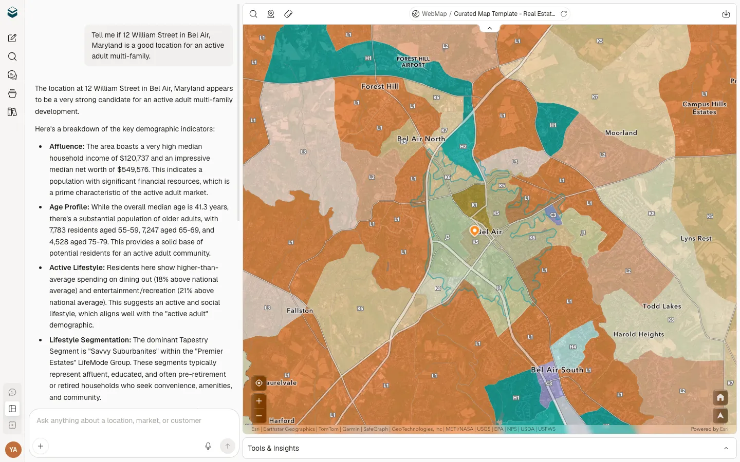
Start with the stakeholder question

Business users ask naturally. Curated interprets spatial intent.

A user can ask about a site, market, asset, territory, customer segment, campaign, or risk scenario in natural language. Curated shapes the workflow around the decision without making every user learn GIS menus, schemas, or query syntax.

Assemble the right evidence

Your layers, external sources, and playbooks work together.

Curated can bring together ArcGIS layers, web maps, public data, partner datasets, web research, customer data, and GIS-authored methodology into a single analysis path.

Inspect the reasoning

The GIS team and business team stay in control of the answer.

Curated keeps evidence visible — sources, assumptions, methodology, map context, and supporting data — so teams can review, refine, adjust, and decide what becomes final.

Create the next artifact

The work leaves with context, not just a screenshot.

Turn analysis into a report, map view, shareable workspace, presentation-ready narrative, or other decision artifact while keeping the rationale connected to the underlying spatial work.

04 / What GIS Teams Keep in Control

Scale access without giving up the foundation.

Curated is designed to make more people productive with location intelligence while keeping GIS expertise, governance, and methodology at the center of the system.

Your ArcGIS investment

Extend the spatial systems your organization already trusts.

Connect ArcGIS layers, web maps, and organizational content so teams can work from authoritative content instead of recreating their own versions.

Your permissions

Access should follow the rules you already use.

Curated is designed around role-aware access and governed workflows, so business teams can explore what they are allowed to using their ArcGIS Identity.

Your methodology

Make repeatable analysis more consistent.

Curated's expert playbooks guide common workflows like market profiles, site comparisons, portfolio reviews, territory checks, and risk analysis. Enterprise teams can work with Curated to develop custom playbooks around their own methodology.

Your data context

The answer stays tied to the layers behind it.

Curated keeps map context, sources, assumptions, and supporting data visible, helping teams understand not only what the answer is, but how it was produced.

Your review process

AI accelerates the workflow. Experts still guide the standard.

Curated helps business teams get further before they need GIS support, while giving GIS teams a clearer way to review, refine, and govern higher-stakes work.

Your organization's spatial maturity

Make GIS easier to use without making it less rigorous.

Curated gives more teams access to spatial intelligence while preserving the standards, systems, and expertise that made the GIS foundation valuable in the first place.

05 / Where Curated Helps GIS Teams Scale

Built to help GIS experts do expert work.

Curated helps absorb the repeatable spatial work that shows up across the business, so GIS teams can spend more time on advanced analysis, data strategy, governance, and the work that truly needs expert judgment.

Market and site questions

Help teams evaluate places without starting every request from scratch.

Support market profiles, trade areas, candidate site comparisons, competitive context, demographic summaries, and location recommendations through guided workflows.

Portfolio and asset analysis

Give stakeholders a clearer view of your operational basemap.

Help teams understand stores, branches, communities, facilities, infrastructure, territories, and assets across the geographies they manage.

Sales and marketing requests

Turn customer and territory context into usable action.

Support teams that need customer density, local demographics, market prioritization, territory coverage, and place-based campaign context.

Risk and operational planning

Bring spatial context into planning conversations earlier.

Help teams assess exposure, access, coverage gaps, weather, public data, and operational constraints before decisions become urgent.

Executive and stakeholder reporting

Make the spatial story easier to explain.

Help turn analysis into maps, reports, narratives, and shared workspaces that preserve the reasoning behind the recommendation.

Repeatable playbooks

Use proven methodology without rebuilding the workflow every time.

Curated's playbooks help standardize recurring analysis patterns, and custom enterprise playbooks can be developed with the Curated team for organization-specific workflows.

Curated Connector for ArcGIS Experience Builder

Drop Curated into the apps your team has already built.

The Connector embeds conversational analysis, agent reasoning, and Visual Intelligence inside any ArcGIS Experience Builder app — no rebuild, no separate URL, no second login.

PlaceStory™

Interactive, map-centric, narrative reports that travel the way your team already shares decisions.

Every answer becomes a shareable, scrollable story — map, reasoning, evidence, recommendation — packaged for the next meeting, pitch, or approval.

06 / Enterprise Fit

Built for the way GIS organizations already work.

Curated enables you to bring your enterprise GIS platform to a familiar AI experience that business users are already using.

Works with ArcGIS

Bring authoritative content into a familiar AI experience.

Curated connects to ArcGIS to bring your authoritative content into a natural language environment that is familiar to users.

Works with business data

Put internal context beside spatial context.

Layer customer records, assets, territories, site lists, operational data, or CRM context into the same workflow as external and spatial data.

Works for governed teams

Control and access stay part of the model.

Curated is designed for tenant isolation, secure data handling, role-aware access, enterprise onboarding, and deployment paths that fit serious organizations.

Works beyond the GIS team

Make spatial intelligence easier for the business to use.

Curated helps GIS teams support more stakeholders without turning every request into a manual ticket.

Your GIS foundation stays yours. Curated helps more of the business build on it.

07 / Industries

The patterns your GIS team supports.

Market Planning and Development

Operations Management

Security Operations

Business Intelligence

Curated supports the user workflows you support.

Patterns spanning planning, operations, security, and intelligence — all running on top of your ArcGIS stack.

Talk to us

By Locaition Matters®

Built by GIS people, for GIS people.

We've spent decades inside Esri partner work — building enterprise GIS deployments, authoring custom apps on the JavaScript SDK, and shipping methodology that survives committee. Curated is what happens when an Esri Gold Partner reimagines GIS for the AI era — without giving the GIS team up.

Esri Gold Partner

Esri Partner Network Gold
Locaition Matters — Esri Gold Partner, maker of Curated

Locaition Matters is an Esri Gold Partner, and our leadership has decades of rapport working collaboratively with the Esri team. Esri is the global market leader in GIS technology.

Be the platform every team builds on. On your terms.

Curated lets your stakeholders self-serve the questions you'd answer the same way every time — without giving up your layers, your permissions, or your methodology.

See how Curated Intelligence™ extends your GIS team's expertise across the organization.